Dampak Teritorial dari Ekstraksi Global
Hilangnya Keanekaragaman Hayati dan Perubahan Iklim
Dari tahun 2002 hingga 2022, Putumayo kehilangan 166.000 hektare hutan hujan primer, yang mewakili 53% dari total kehilangan tutupan pohon. Total luas hutan hujan primer di Putumayo menurun 9,8% dalam kurun waktu tersebut. Dari tahun 2001 hingga 2022, Putumayo kehilangan 323.000 hektare tutupan pohon, setara dengan penurunan tutupan pohon sebesar 14% sejak tahun 2000, dan 229 juta ton emisi CO2. Dua wilayah utama tersebut menyumbang 55% dari seluruh kehilangan tutupan pohon antara tahun 2001 dan 2022. Puerto Guzman mengalami kehilangan tutupan pohon tertinggi dengan 96.700 hektare dibandingkan dengan rata-rata 26.900 hektare. Menurut SIAC (Sistema de Informacíon Ambiental de Colombia), deforestasi di Putumayo lebih tinggi antara tahun 2002 dan 2007, kemudian menurun antara tahun 2012 dan 2014, dan dari tahun 2018 hingga 2020 deforestasi kembali meningkat.
From 2001 to 2022, Putumayo lost 21,9000 hectares of tree cover to fire and 301,000 hectares to other loss factors. During this period, the year with the greatest loss of tree cover due to fires was 2022 with 2,750 hectares lost, 9.6% of the total loss of tree cover for that year.
Between 2001 and 2022, an annual average of 10.4Mt was emitted to the atmosphere as a result of the loss of tree cover in Putumayo. In total, 229Mt of CO₂e emissions were recorded during this period.
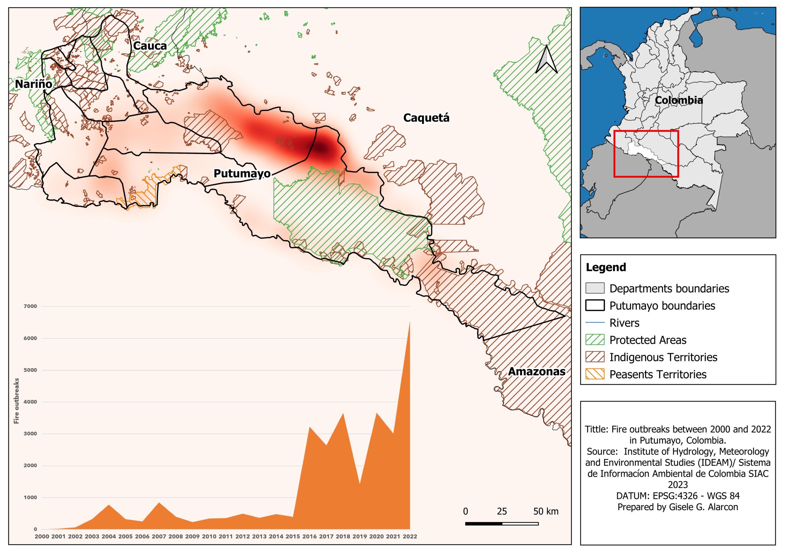
Number of fire outbreaks accumulated between 2000 and 2022 at the Putumayo Department, Colombia.
In Putumayo, between 2020 and 2022 fire outbreaks increased 78%, reaching 6,532 spots. The region with historical concentration of fires is in the border with Caquetá, in an area contiguous with pasture expansion in the neighboring Department.
Environmental Justice
The area was highly affected during the conflict by guerrilla and paramilitary groups, creating a highly militarized and socially broken society. This means that there was also a shift from common subsistence agriculture to illegal crops and other activities like artisanal mining. Moreover, the area has oil reserves which resulted that since the 2000s the national government started official interest exploration of the crude oil resources in the areas. In 2006 oil exploitation began (with a daily production of 2,500 to 3,000 barrels). In total in the Department there are 120 currently active wells (generating approximately 12,631 barrels per day). Regarding the current economic activity, the most important economic activities of Putumayo are public services and extraction of non-renewable resources. The largest oil production site is located in the Orito-Puerto Colón region. Moreover, cattle ranching and agriculture are also important economic drivers (Ministerio de Comerciao, Industria y Turismo).
In Putumayo most environmental conflicts are caused by mining of minerals and crude oil, illegal crops and livestock activities. The region has a severe history of massacres and presence of the FARC (Revolutionary Armed Forces of Colombia) and other armed groups. Illegal mining is a common activity and has been severely condemned by the government who tend to destroy illegal mining sites.
The presence of multinationals in the department is very strong, especially considering crude oil mining. Arising problems from this sector is most commonly forced displacement, water contamination and even coordinated action with paramilitary groups. With 64 killed land and environmental defenders in 2019, Colombia is leading the global statistics (Global Witness 2020).
When considering Putumayo region, there are three reported cases by the Environmental Justice Atlas, falling into the following categories: i. Mineral ores and building materials extraction, ii. Fossil fuels and climate justice/energy and iii. Biomass and land conflicts (forests, agriculture, fisheries and livestock management).
| Name of conflict | Type of conflict 1st level | Type of conflict 2nd level | Specific commodities |
|---|---|---|---|
| Oil Exploitation Puerto Vega, Teteyé corridor | Fossil fuels and climate justice/Energy | Establishment of reserves/national parks. Water access rights and entitlements. Oil and gas exploration and extraction | Crude oil |
| La Vega-Mocoa Project (Cauca, Putumayo) | Mineral Ores and Building Material Extractions | Land acquisition conflicts. Mineral ore exploitation. | Copper, Gold, Molibdeno |
| Aerial Fumigation with glyphosate in the Putumayo, Colombia | Biomass and land conflicts (Forests, Agriculture, fisheries and Livestock Management) | Deforestation, military installations, Agro-toxics | Pesticides, Land, Water |
